


💛 A quick favor, if you've got a second.
We're really happy that you chose to read one of our stories and sincerely hope you'll stick around to read more. We took our paywall down — for now — but that won't last forever, and when the gate goes back up, we'd love for you to already be on the inside.
It's free. So please enter your email here and don't forget to like and follow us on all of your favorite Social Media platforms!
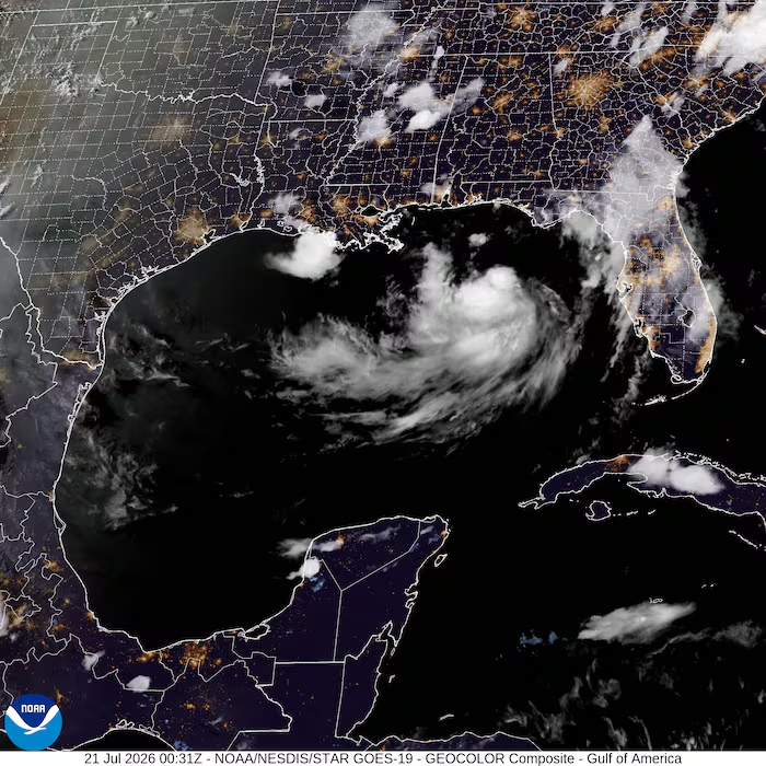
Tropical Storm Bertha intensified over the Gulf of Mexico and tracked gradually northwestward toward the Florida Panhandle early Tuesday, prompting the National Hurricane Center to issue tropical storm warnings and storm surge watches spanning the Florida-Alabama border region and portions of Louisiana. The Miami-based center reported the system positioned approximately 125 miles south of Panama City, Florida, and 200 miles southeast of Mobile, Alabama, advancing at just 2 mph with maximum sustained winds reaching 50 mph.
Wind speeds have increased 10 mph since Bertha’s formation Monday evening. A tropical storm warning extends from the Florida-Alabama state line to the Jefferson and Plaquemines parish boundary in Louisiana, with conditions expected within 36 hours of the warning. Storm surge watches cover the same northern boundary through the mouth of the Mississippi River, with forecasters warning of potentially life-threatening water rises up to 4 feet in portions of Louisiana, Alabama, and Florida.
Heavy rainfall totaling 3 to 5 inches along Louisiana’s coastline and isolated tornadoes over Florida’s Big Bend region remain possible through Friday. Flash flooding threatens coastal areas from western Florida to central Texas, with emergency officials in Escambia County, Florida, distributing sand for sandbag preparation in flood-prone communities.
Bertha ranks as the Atlantic hurricane season’s second tropical storm, following Tropical Storm Arthur’s June rainfall across the Southeast. In the Pacific Ocean, Hurricane Fausto formed 745 miles southwest of Baja California’s southern tip with 75 mph winds, posing no immediate land threat but generating dangerous ocean swells near the Mexican coast.

More Stories
Colombia backs Trump security push while limiting U.S. role in anti-gang operations
Chicago Mayor Issues Executive Order Requiring Contractor Diversity Disclosures and ICE Ties Reporting
University of Pennsylvania Climate Scientist Demands Supreme Court Packing Pledge From Democratic Candidates