


💛 A quick favor, if you've got a second.
We're really happy that you chose to read one of our stories and sincerely hope you'll stick around to read more. We took our paywall down — for now — but that won't last forever, and when the gate goes back up, we'd love for you to already be on the inside.
It's free. So please enter your email here and don't forget to like and follow us on all of your favorite Social Media platforms!
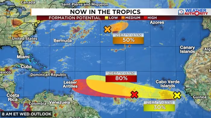
Artificial intelligence-driven forecast models made a significant pivot Tuesday, identifying a nascent tropical wave emerging from Africa as the next potential development candidate for the Atlantic basin. Google’s DeepMind and the European Union’s AI modeling system both showed considerably stronger interest in the long-range prospects of this system compared to conventional physics-based models, which have yet to formally embrace the signal. The National Hurricane Center introduced the wave in its tropical outlook Tuesday evening with initially low odds of formation during the current week.
Meanwhile, system 92L—which the National Hurricane Center continues to rate with high probability for near-term tropical depression or storm development—faces increasingly grim conditions as it approaches the eastern Caribbean. Forecast models have substantially reduced their long-term expectations for the system as it moves westward into the islands this weekend, with the stronger northern-track scenarios now considered unlikely. A thick band of dry air and intensifying wind shear are expected to severely hamper any strengthening efforts through the weekend.
The most probable scenario shows 92L as a weak tropical depression or minimal tropical storm, tracking westward into the Caribbean, Lesser Antilles, Virgin Islands, and Puerto Rico from late weekend into early next week. While the system could deliver beneficial rainfall to drought-stricken Caribbean islands through Monday, widespread heavy rain impacts are not anticipated at this time. The timing and track remain conducive to moderate precipitation rather than catastrophic weather impacts for residents and territories in its path.
Hawaii residents face elevated weather threats from system 93C, a central Pacific disturbance positioned approximately 1,000 miles southeast of the islands and expected to develop into Tropical Storm Lala within days. Forecast models indicate modest strengthening with a projected track bringing the system near or over portions of Hawaii this weekend. Warmer-than-normal central Pacific waters this season increase the possibility of hurricane-strength impacts, an unusual but not unprecedented occurrence for the island state.
Hawaii’s extreme geography means even relatively modest tropical cyclones can produce significant impacts in densely populated areas like Oahu, where tropical threats remain uncommon. Residents and visitors throughout the islands—including the Big Island, Maui, Oahu, and Kauai—should monitor forecasts closely in coming days and begin implementing precautionary measures. Dangerous surf conditions and heavy weather impacts represent the primary concerns as the system approaches the islands this weekend.
The shift in Atlantic activity underscores the onset of peak hurricane season, typically the most active six-week stretch annually. Despite expectations for below-normal overall activity this season due to El Niño conditions, the Atlantic basin requires only modest pockets of favorable atmospheric conditions to generate major hurricanes, even during historically quieter years.


More Stories
Massachusetts Democrats Split on Age Issue as Moulton Challenges Incumbent Markey in Primary
Hurricane Karina Intensifies Over Pacific, Potential Major Storm Looms This Week
Humidity Expected to Build Sunday With Chance of Evening Storms