
💛 A quick favor, if you've got a second.
We're really happy that you chose to read one of our stories and sincerely hope you'll stick around to read more. We took our paywall down — for now — but that won't last forever, and when the gate goes back up, we'd love for you to already be on the inside.
It's free. So please enter your email here and don't forget to like and follow us on all of your favorite Social Media platforms!
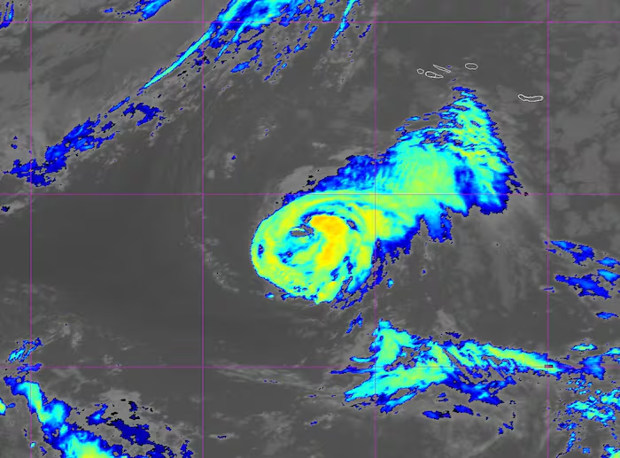
Tropical Storm Fay – the 6th named storm of the historically inactive 2026 Atlantic hurricane season – formed quickly over the weekend over the far northeastern Atlantic and made an unexpected run as the season’s first hurricane by Sunday evening.Ultimately Fay fell just short of the 74 mph hurricane threshold, topping out as a 70 mph tropical storm Sunday night before quickly crumbling to a curtain of wind shear early Monday.Fay was poorly forecast or missed entirely by our major forecast models late last week. Models mostly keyed in on the disturbance designated Invest 98L over the central Atlantic last week – which we discussed in detail in this newsletter much of last week – while either downplaying or overlooking the potential development of the low-pressure system that became Fay southwest of the Azores.The National Hurricane Center didn’t first include the disturbance in its outlook until Friday morning – only 24 hours before it formed – and with low odds that sharply rose during the day Friday.Fay finds a windowFay formed almost as far north and east as we’ve recorded an Atlantic named storm in September, in a part of the basin that’s historically hostile to tropical development this time of year.But waters in the area where Fay formed are at record warmth for the time of year and, with a narrow window of light upper-level winds, Fay made the most of its short stint as a tropical system.Forecast models historically struggle with initially non-tropical systems like Fay that form in the far corners of the North Atlantic and outside of the traditional tropical belt. Back in September 2012, the system that was forecast to top out as a 40 mph Tropical Storm Michael over the open middle Atlantic became 115 mph Category 3 major Hurricane Michael (different from 2018’s catastrophic Hurricane Michael that struck the Florida panhandle) less than three days later.It’s a good reminder that while hurricane forecasts are one of the best success stories in all of predictive sciences, forecast models can still miss in dramatic fashion, especially for unconventional situations or during seasons that don’t behave like others in the historical record.Upcoming nor’easter with a small chance of turning tropicalAn area of low pressure that’s expected to develop along a stalled cold front over the western Atlantic later this week will drift westward toward the Mid-Atlantic and Northeast U.S. as it strengthens into the weekend.While the exact track of the low-pressure is still uncertain, the difference in high pressure over Central Canada and the intensifying low to the southeast over the western Atlantic will crank up winds and whip up seas along the Eastern Seaboard from the Outer Banks of North Carolina to New England from Thursday through Saturday. This could produce a prolonged nor’easter-like event for the region, with strong, gusty winds above 40 mph, multiple cycles of coastal flooding, coastal erosion, and periods of heavy rain depending on the eventual track of the low-pressure system.For now, the system looks to stay non-tropical, but there’s a small chance (~20% chance) its core warms enough so that it transitions to a tropical system later this week into the weekend. Both the AI models and traditional, physics-based models agree on this low probability scenario so it’s something to follow. Regardless, it shouldn’t appreciably change the impacts expected for the coast later this week.
/* Prevent width calc overflow across the component */
.l10-hurribox, .l10-hurribox * { box-sizing: border-box; }
.l10-hurribox {
–bg-deep: #0a2540;
–bg-sky: #0e5a8a;
–accent-red: #e6402f;
–accent-blue: #2e63b6;
–steel: #cfd6dd;
–text: #f5f7fa;
–text-dim: #e0e6ee;
–shadow: 0 10px 30px rgba(0,0,0,.35);
font-family: system-ui, -apple-system, Segoe UI, Roboto, “Helvetica Neue”, Arial, sans-serif;
max-width: 860px;
margin: 1.25rem auto;
border-radius: 14px;
color: var(–text);
position: relative;
overflow: hidden;
box-shadow: var(–shadow);
background:
radial-gradient(1200px 600px at 50% -10%, rgba(84,199,255,.18), rgba(84,199,255,0) 55%),
linear-gradient(180deg, var(–bg-sky) 0%, var(–bg-deep) 60%);
}
.l10-inner { position:relative; z-index:1; padding: 18px 18px 72px; }
/* Header */
.l10-header {
display:flex; align-items:center; gap:14px;
background: linear-gradient(90deg, #101820, #14283d 60%, rgba(16,24,32,0));
border: 1px solid rgba(255,255,255,.08);
padding:14px 16px; border-radius:10px;
}
.l10-flag { flex:0 0 auto; width:44px; height:32px; filter: drop-shadow(0 3px 4px rgba(0,0,0,.4)); }
.l10-title { line-height:1.2; font-weight:800; font-size: 1.2rem; color:#fff; }
.l10-title .top { font-size: .95rem; color: var(–steel); opacity:.95; display:block; }
/* Grid: fixed breakpoints (1 -> 2 -> 4 columns) to avoid squeeze/overlap */
.l10-grid{
display:grid; gap:14px; margin-top:18px;
grid-template-columns: 1fr;
align-items: stretch;
}
@media (min-width:600px){
.l10-grid{ grid-template-columns: repeat(2, minmax(0,1fr)); }
}
@media (min-width:900px){
.l10-grid{ grid-template-columns: repeat(4, minmax(0,1fr)); }
}
/* Buttons / cards: compact + equal height */
.l10-btn {
display:flex; flex-direction:column;
justify-content:flex-start;
height:100%;
min-height:120px; /* smaller card height */
padding:16px 14px; /* tighter padding */
border-radius:12px; text-decoration:none;
font-size: 1rem;
border:1px solid rgba(255,255,255,.1);
background:
linear-gradient(180deg, rgba(255,255,255,.06), rgba(255,255,255,.02)),
radial-gradient(220px 120px at 110% -20%, rgba(84,199,255,.35), transparent 50%),
linear-gradient(180deg, #14345c, #0d2745 60%, #0b213a 100%);
color:#fff;
box-shadow: var(–shadow);
transition: transform .12s ease, box-shadow .12s ease, border-color .12s ease;
word-break: break-word; /* wrap long bits safely */
min-width: 0;
}
/* even more compact on very small screens */
@media (max-width:400px){
.l10-btn{ min-height:110px; padding:14px 12px; }
}
.l10-btn:hover, .l10-btn:focus-visible {
transform: translateY(-1px);
box-shadow: 0 12px 24px rgba(0,0,0,.42);
border-color: rgba(255,255,255,.22);
outline: none;
}
/* Keep text white after visit */
.l10-btn:link, .l10-btn:visited { color: #fff; }
.l10-btn .l10-label, .l10-btn .l10-kicker, .l10-btn .l10-pill { color: inherit; }
.l10-kicker {
font-size:.78rem; letter-spacing:.1em; text-transform:uppercase;
color: var(–text-dim);
display:flex; align-items:center; gap:6px;
}
.l10-kicker svg { width:16px; height:16px; flex:0 0 auto; }
.l10-label { font-size: 1.02rem; font-weight:800; line-height:1.2; margin-top:4px; }
/* Bottom-anchored pill so rows align */
.l10-pill {
margin-top:auto;
padding:5px 10px; border-radius:999px;
background: linear-gradient(90deg, var(–accent-blue), #5c87e2);
color:#fff; font-weight:700; font-size:.74rem;
}
/* Wave */
.l10-wave { position:absolute; left:0; right:0; bottom:-1px; height:68px; z-index:0; pointer-events:none; }
.l10-wave svg { width:100%; height:100%; display:block; }
Local 10
Hurricane Resources
Section
Hurricane Section
Latest coverage
Analysis
Talking Tropics
Daily updates
Guide
2026 Survival Guide
Prep & checklists
Special
‘It Only Takes One’
Watch & learn
More Stories
NFL Week 2: Final scores, what the national media is saying about your team
Carrot Top ‘breathing on his own’ as his health improves, publicist says
Presley Gerber, son of Cindy Crawford and Rande Gerber, dead at 27: A life in photos