


💛 A quick favor, if you've got a second.
We're really happy that you chose to read one of our stories and sincerely hope you'll stick around to read more. We took our paywall down — for now — but that won't last forever, and when the gate goes back up, we'd love for you to already be on the inside.
It's free. So please enter your email here and don't forget to like and follow us on all of your favorite Social Media platforms!
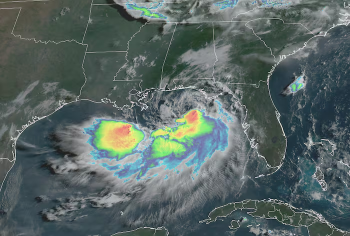
Tropical Depression Two upgraded to Tropical Storm Bertha on Monday evening after NOAA Hurricane Hunters confirmed 40 mph winds approximately 120 miles south of Panama City Beach, Florida, marking the second named storm of the 2026 Atlantic hurricane season. The storm’s positioning in the northeastern Gulf of Mexico places it ahead of the 30-year average for the second named storm, which typically forms around July 17.
Investigators observed a disorganized storm structure during Tuesday morning reconnaissance flights, with thunderstorms attempting to develop near an exposed center. Wind shear conditions remain elevated and are forecast to intensify in coming days, constraining any potential strengthening to a brief window and ensuring sustained organizational gains remain unlikely.
The upper-level wind pattern driving high wind shear will skew Bertha’s circulation, concentrating heavier precipitation and more severe weather south of the center while leaving the northern side relatively dry. Rainfall exceeding one foot will remain predominantly offshore, limiting widespread coastal flooding threats as the system moves westward along the northern Gulf Coast.
Bertha poses a limited threat to coastal communities, expected to peak as a mid-tier tropical storm with maximum winds between 50 and 60 mph before weakening commences Wednesday. Tropical Storm Warnings extend from extreme southeastern Louisiana to the Alabama-Florida border, though damaging winds should remain confined to rain squalls and isolated gusts.
Parts of the Florida Panhandle, coastal Alabama, and southern Mississippi and Louisiana may experience localized flooding through Thursday from outer rain bands. Treacherous beach conditions and life-threatening rip currents are anticipated along northern Florida and Alabama shorelines, posing significant danger to swimmers and beachgoers throughout the week.
Activity elsewhere in the Atlantic basin remains dormant with no development candidates expected for at least several weeks. Forecasters will continue monitoring subtropical zones, including gulf formations similar to where Bertha originated, though the near-term outlook shows minimal organizational potential.

More Stories
Forest Service Proposes Steep Fee Increases at Lake Tahoe Recreation Sites
Son Discovers Father Missing After Himalayan Disaster in Nepal-Tibet Border Region
Month-Long HEPA Use Linked to Faster Cognitive Processing in Middle-Aged Adults