


💛 A quick favor, if you've got a second.
We're really happy that you chose to read one of our stories and sincerely hope you'll stick around to read more. We took our paywall down — for now — but that won't last forever, and when the gate goes back up, we'd love for you to already be on the inside.
It's free. So please enter your email here and don't forget to like and follow us on all of your favorite Social Media platforms!
The Atlantic basin is expected to remain quiet through the early portion of next week, but meteorological models are increasingly signaling the potential for tropical system development by late next week. A robust tropical wave is forecast to emerge over the eastern Atlantic around August 25-26, presenting conditions that forecasters are monitoring closely across multiple modeling platforms including both artificial intelligence and traditional physics-based prediction systems.
While development of this system remains uncertain, the consistency of the signal across major forecasting models represents the strongest indication observed during the current seasonal period. Earlier waves designated as Invest 92L and Invest 94L showed similar promise in initial model runs before failing to organize in subsequent forecast cycles. Even with the current system, some model disagreement persists, with Google’s DeepMind reducing its confidence levels in recent overnight updates.
Conditions in late August and early September are climatologically more favorable for tropical system development than earlier periods in the month. The Atlantic basin enters a more active phase heading into fall, creating an environment more conducive to organization and strengthening. Most Atlantic systems will continue to struggle this season, but the late summer period presents elevated risk similar to peak summer activity in other regions.
A significant advantage of potential development occurring over the open Atlantic is the extended warning period available for coastal communities to monitor and prepare. No tropical threats are anticipated for the Atlantic side through at least the end of next week, allowing forecasters additional time to track any emerging system.
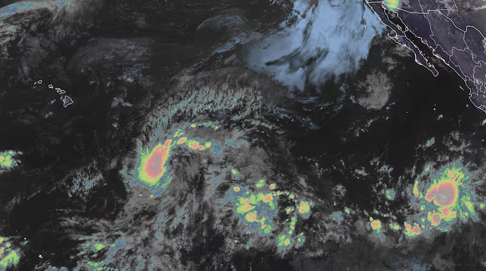
Hawaii faces a more immediate concern as Invest 90E, positioned approximately 1,000 miles southeast of the islands, is expected to gradually organize into a tropical depression and named storm designated as Moke in the coming days. The system’s general track suggests potential proximity to Hawaii during the upcoming weekend, though model confidence remains limited until the system fully develops.
State officials continue assessing damage and beginning recovery operations following Hurricane Lala, which impacted the islands last weekend. While atmospheric conditions appear less favorable for significant strengthening compared to Lala’s development, indirect threats remain substantial given the islands’ compromised infrastructure and elevated water levels from the previous system’s heavy rainfall.

More Stories
New York’s Colombian Community Mobilizes Relief Efforts Following Recent Earthquakes
Nepal Buries Hundreds of Flood Victims in Mass Graves as Identification Efforts Lag
Hurricane Karina Intensifies Over Pacific, Potential Major Storm Looms This Week